
The processes of erosion and deposition create different river landforms. River landscapes change as you go downstream from the source to the mouth. In the upper course of a river, steep gradients lead to rapid-flowing rivers. In the middle course, the river meanders through gentle gradients. In the lower course, the river braids over flat land.
Meanders and Ox-bow lakes Meanders are bends in a rivers course. Water flowing around a meander moves fastest on the outside of the bend leading to erosion and the formation of a steep river cliff. On the inside of the bend, water slows down leading to the deposition of sediment. This forms a gently-sloping slip off slope in the shallow water. Lateral erosion by meanders leads the widening of the valley floor (floodplain). Meanders often migrate downstream and become wider and larger over time. Where there are well developed meanders, a river may take a short-cut across a narrow meander neck in times of flood and this leads to the creation of sections of abandoned river called ox-bow lakes. Over time, the ox-bow lakes dry up and leave just a meander scar.

Flood plains A flood plain is the wide, flat area of land on either side of the river in its middle and lower course. A flood plain forms through both erosion and deposition. When material is deposited on the slip off slope of a meander it gradually builds up over time. When a river overflows its banks, water pours on to the floodplain and as it drains away fine material (alluvium) is deposited.
Deltas A delta is a flat area of sand and silt built into the sea. When a river enters the sea carrying large volumes of fine material, the velocity slows and causes the load to be deposited in layers. Over time, the deposited material forms small islands separated by river channels called distributaries.
Waterfalls A waterfall is a steep drop in the course of a river. They form when a band of hard resistant rock (cap rock) lies over softer, less resistant rock. The softer rock is quickly eroded by hydraulic action and abrasion, causing the harder rock to be undercut. The hard rock overhangs until it can no longer carry its own weight. The overhang collapses and then breaks up in the water below. The great power of the water at the base of the waterfall causes a plunge pool to form. The bed of the river below the waterfall contains boulders eroded by splash back from behind the waterfall.

Coastal landforms, any of the relief features present along any coast, the result of a combination of processes, sediments, and the geology of the coast itself. The coastal environment of the world is made up of a wide variety of landforms manifested in a spectrum of sizes and shapes ranging from gently sloping beaches to high cliffs, yet coastal landforms are best considered in two broad categories: erosional and depositional. In fact, the overall nature of any coast may be described in terms of one or the other of these categories. It should be noted, however, that each of the two major landform types may occur on any given reach of coast.
Headlands are usually formed of more resistant rock types than bays. If there are different bands of rock along a coastline, the weaker or softer rock, such as clay, is eroded fastest. This leaves more resistant rock types, such as granite, sticking out.

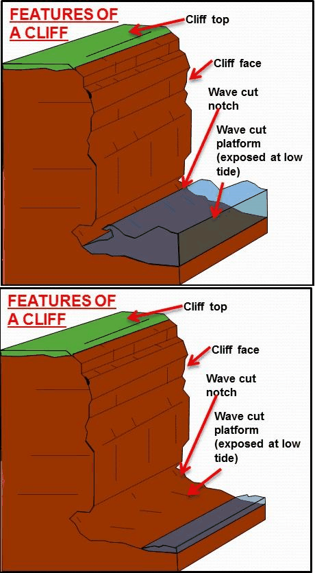
Cliffs and cliff retreat
A cliff is a vertical, near vertical or sloping wall of rock or sediment that borders the sea. They generally differ in their angle of slope because of their rock structure and geology, but the processes involved in their formation are the same.
